
Camden Street (South) Area Safe and Healthy Streets
Results updated 31 Jan 2025
During July and August 2024 we consulted on changes proposed for the Camden Street (south) area.
Thank you to everyone who took the time to share their views. We had 130 responses and following the consultation, we have made the decision to implement the proposed changes as a permanently.
A notification will now go to all local residents, businesses and stakeholders and our construction contractors will be in touch ahead of any work starting.
You can read the decision reports relating to this and our feedback to the consultation responses in the decision report.
Links:
Overview
We want our streets to have more safe space for everyone to walk and cycle, for children to get to and from school safely and healthily, for businesses to be able to flourish, to reduce carbon emissions from vehicles and for you to be breathing cleaner air.
We want our streets to provide a lasting legacy of greener, safer, healthier travel.
69% of households in Camden do not own a car, and around 85% of all trips by Camden residents are made on foot, by bike or on public transport. Supporting and encouraging those who can to walk and cycle, by creating safer, healthier streets, will help ensure that there is more space available on public transport and on our roads for those who need it the most.
In line with our Camden Transport Strategy, Climate Action Plan, and Clean Air Action Plan, and to continue supporting safe, healthy, and active travel, we have been making changes across Camden as part of our Safe and Healthy Streets Programme.
In order to create safer and healthier streets we are proposing several new permanent measures in the Camden Street (south) area, as summarised below.
Scheme Background & Context
Several streets located to the east of Camden Street between Camden Road and Crowndale Road have seen an increase in motor vehicle traffic following Transport for London (TfL)’s introduction of a banned left turn for southbound vehicles on Camden Street, at the junction with Camden Road, in 2021.
Georgiana Street, Lyme Street and Pratt Street are located on Camden’s local street network and are primarily residential in nature, with Pratt Street also being home to Our Lady's Catholic Primary School. In response to concerns raised by local residents and stakeholders regarding increased general and Heavy Goods Vehicle (HGV) traffic on these streets following the introduction of the TfL scheme noted above, we commissioned traffic counts in the area.
Monitoring Data (traffic counts)
Traffic counts were undertaken both before and after the TfL banned left turn was introduced for southbound vehicles on Camden Street, at the junction with Camden Road, in 2021. The table below presents the ‘before’ and ‘after’ average weekday 12 hour (7am – 7pm) traffic flows on Georgiana Street east of Camden Street (eastbound), Lyme Street north of Georgiana Street (northbound) and Pratt Street east of College Place (eastbound). Whilst the COVID-19 pandemic and related lockdowns (March - June 2020 and January - July 2021) significantly affected traffic flows, the counts below were conducted outside these periods, so the data is likely to reflect normal traffic conditions.
|
Location |
Mar-19 |
Jan-20 |
Oct-22 |
Change |
||
|
No. |
% |
|||||
|
Georgiana Street east of Camden Street (Eastbound) |
|
261 |
840 |
+579 |
222% |
|
|
Lyme Street north of Georgiana Street (Northbound) |
|
41 |
168 |
+127 |
310% |
|
|
Pratt Street east of College Place (Eastbound) |
1,143 |
|
942 |
-201 |
-18% |
|
As outlined in the table above there has been a substantial increase in traffic on both Georgiana Street (up 222%) and Lyme Street (up 310%) and a slight reduction in traffic on Pratt Street (down 18%) compared to before the TfL banned left turn was introduced.
Following the above monitoring information and stakeholder feedback, we are now proposing a number of Safe and Healthy Streets changes on streets to the east of Camden Street, south of Camden Road. These changes, if approved following consultation, would reduce through traffic and improve road safety on local streets such as Georgiana Street, Lyme Street and Pratt Street. In addition, we are proposing new measures to enhance the street environment, improve accessibility for pedestrians and cyclists and reduce road safety risks. The proposals would encourage more children to walk, cycle or scoot to schools in the area, with less air pollution, road danger, congestion, and more space for people to stop and chat.

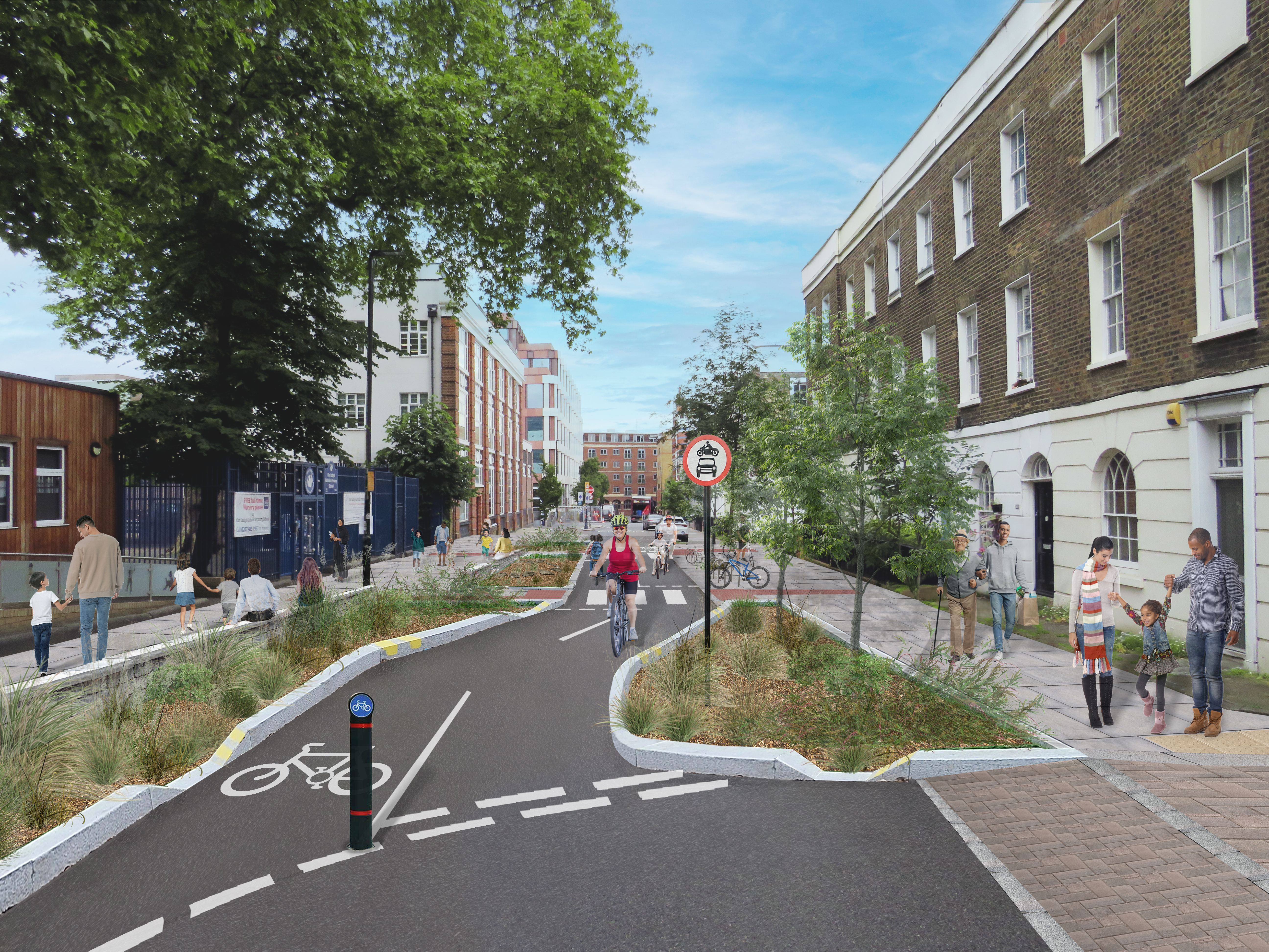
Visualisation of proposed measures on Pratt Street
What are we proposing?
The proposals are set out in the sections below:
Through Traffic Motor Vehicle Restrictions
We are proposing to introduce the following specific measures to reduce through-motor traffic movements in this area:
- A camera-enforced motor vehicle restriction on Georgiana Street to the west of Royal College Street,with access for cycles, emergency service and other exempt vehicles only. Access/egress for all other vehicles on Georgiana Street between Camden Street and Royal College Street would be via Camden Street only. This restriction would prevent eastbound motor vehicles from using Georgiana Street as an alternative route from Camden Street (north) to Camden Road (east), in light of the TfL banned left turn scheme. It should be noted that a restriction already exists for westbound motor vehicle traffic on Georgiana Street, at the junction with Royal College Street, therefore this proposed restriction would eliminate two-way through traffic movements, whilst keeping access to local properties in the area.
- A physical motor vehicle restriction (lockable bollard), with cycles exempt, on Lyme Street at the junction with Georgiana Street. Access/egress for all other vehicles on Lyme Street would be via Camden Road only. Similar to the above, this restriction would prevent motor vehicles from using Lyme Street as an alternative route from Camden Street (north) to Camden Road (east), in light of the TfL banned left turn scheme, whilst keeping access to local properties in the area.
- A pedestrian and cycle-only zone on Pratt Street between the junctions of Mandela Street and College Place to prevent vehicles moving over from using Georgiana Street and Lyme Street, to Pratt Street. Access for all vehicles on Pratt Street (west of the pedestrian and cycle only zone) and Mandela Street would be via Camden Street only and egress would be via Plender Street. Access for all vehicles on Pratt Street (east of the pedestrian and cycle only zone) and College Place would be via Royal College Street only and egress would be via Plender Street. The closure of this section of Pratt Street would enable the delivery of a two-way cycle facility (the first phase of the Cross Camden Cycleway) and several street improvements to take place, as discussed in the sections below.
- A one-way system (except for cycles) outside of the proposed pedestrian and cycle only zone on Pratt Street eastbound from Camden Street and westbound from Royal College Street, southbound on Mandela Street (between Pratt Street and Plender Street) and southbound on College Place (between Pratt Street and Plender Street). This would help to reduce motor vehicle conflicts and help with traffic flows in the area, whilst retaining access to local properties.
These proposals would include relevant advanced warning signage alerting all road users to the restrictions.
Whilst some motor vehicle journeys in some directions may require alternative routes as a result of these restrictions, local access to every property in the area would be kept. The map below shows the motor vehicle access routes that would be available, subject to a decision to implement the scheme.

Healthy School Street (timed road closure)
We are also proposing a Healthy School Street (timed road closure) near Our Lady's Catholic Primary School, which has an entrance on Pratt Street. Healthy School Streets create a safer and healthier environment by temporarily closing roads to motor traffic outside schools during drop-off and pick-up times. This enables more children to walk, cycle or scoot to school, with less air pollution, road danger, congestion, and more space for people to stop and chat. Healthy School Streets, of which there are 31 such schemes in the Borough, help to discourage car trips, particularly amongst parents and carers, by providing a safe and inviting spaces for more walking, cycling and scooting.
The proposed Healthy School Street (timed road closure) would operate on:
-
- Pratt Street (outside of the proposed pedestrian and cycle only zone) between Camden Street and Royal College Street;
- Mandela Street (between Pratt Street and Plender Street); and
- College Place (between Pratt Street and Plender Street).
The Healthy School Street would operate for 1 hour during pupil drop-off (8 - 9am) and pick-up (3 - 4pm) times.
We have collected traffic count data at a number of locations in the area across an average week during school term time which shows that traffic volumes on these streets are at some of their highest levels during school run times. The graph below outlines the traffic count data collected on Pratt Street (in October 2022), where Our Lady's Catholic Primary school is located.

The scheme would include relevant signage alerting drivers to the restrictions at the start of each restricted section on the above roads. The Healthy School Street signage would state the times of the road closures and would be closed during school holidays.
The following vehicles would be exempt from the timed Healthy School Street restrictions by applying for an exemption.
- Vehicles registered to properties and businesses located within the timed restriction area on Pratt Street (between Camden Street and Royal College Street), Mandela Street (between Pratt Street and Plender Street) and College Place (between Pratt Street and Plender Street). Exemptions would need to be applied for and agreed with the Council. The timed restriction area/exemption area is shown in green in the map below.
- Vehicles belonging to parents with a Blue Badge who have a pupil attending Our Lady's Catholic Primary School or parents/carers of pupils of the school that have a disability that prevents them from walking, cycling, or scooting to school (exemptions would need to be agreed with the Council).
Emergency services such as ambulance, fire brigade or police, Door to door services such as Plus Bus and Dial a Ride and refuse collection vehicles and other statutory services will be automatically exempt.
School staff and visitors to the schools would not be exempt. Taxis and delivery vehicles would not be exempt, and such trips would need to be scheduled outside of the restricted times or the vehicles would need to be parked outside of the restricted area. However, exemptions can be applied for in exceptional circumstances, such as when elderly or disabled people may need essential taxi journeys during the restricted hours. All the requests for exemptions can be applied for by contacting the Healthy School Streets team over the phone or via email. If the scheme goes ahead, details of how to apply for an exemption will be posted to residents and businesses in the consultation area.
Below is an overview map showing the proposed motor vehicle restrictions on Georgiana Street, Lyme Street and Pratt Street alongside the proposed Healthy School Street (timed road closure).

Other Safe and Healthy Streets proposals
We are also proposing several additional pedestrian, cycle, road safety, public realm and environmental improvements in the area, as detailed below.
Georgiana Street / Lyme Street
- Wider pavements on Georgiana Street and Lyme Street are proposed to create more space for pedestrians and improvements to the look and feel of the area such as planting and rain gardens (for an example image see our photo guide). .
Pratt Street / Mandela Street / College Place
- Wider pavements on Pratt Street are proposed to create more space for pedestrians outside Our Lady's Catholic Primary School and improvements to the look and feel of the area such as planting and rain gardens, potential children's play equipment, seating and cycle parking.
- Blended/continuous crossings at the Mandela Street and College Place junctions with Pratt Street. Blended/continuous crossings help to slow down vehicles when entering or exiting side roads and encourage vehicles to give way to pedestrians crossing the road (for an example image see our photo guide).
- Adding a dockless e-scooter and cycle hire bay, two cycle hangars and an electric vehicle charging station on Pratt Street to the west of Mandela Street. These facilities would help to meet demands in the area for secure cycle storage and improve opportunities to access to active and sustainable travel options.
- Removing a redundant vehicle crossover on Pratt Street (between College Place and Royal College Street), to improve pedestrian accessibility and enhance the look and feel of the street.
Plender Street
- A new zebra crossing on Plender Street to the east of College Place to make it easier and safer for pedestrians to cross the road.
Other
- Extension of double yellow lines at various junctions in the scheme area as part of Camden’s Junction Protection Programme, to ensure that vehicles are not able to park within at least 10 metres of a junction at any time of the day. This would improve pedestrian visibility and therefore reduce road safety risks at junctions.
To accommodate the proposed changes above, would require amendments to kerbside space as per the table below.
|
Type |
Approx. m of kerbside space removed |
|
Permit holder only parking (CA-G/F) |
42m (approx. 8 parking spaces) |
|
Pay by phone parking |
19m (approx. 4 parking spaces) |
|
Solo motorcycle parking |
12m (alternative solo motorcycle parking is available approx. 150m to the west, between Bayham Street and Camden Street) |
To view the proposed scheme plans, a visualisation showing what the pedestrian and cycle only zone on Pratt Street could look like and our example photo guide, click on the links in the Related section at the bottom of this page.
Camden High Street
In addition in this general area, we are also now consulting on trial changes to Camden High Street including a pedestrianised area between the junction with Parkway and Kentish Town Road to the junction with Jamestown Road and Hawley Crescent alongside other trial changes on Buck Street and Jamestown Road. The consultation for Camden High Street is open until 30 August 2024. Please use this link to Share your views on that separate scheme.
Why your views matter
Your views are important in providing feedback on the proposed scheme as a whole, and elements of it, and we would therefore welcome your responses to the questions on the pages that follow. The Council will be pleased to hear your views, as well as any alternative suggestions or objections you may have to any aspect of what we are proposing.
After the consultation, a decision report will be produced and published online via our website. Local residents and stakeholders will be notified of the outcome. The report will consider a broad range of information including officer observations, consultation responses, relevant policies, and other data/information.
Subject to a decision to implement the scheme, officers would continue to monitor the scheme and consider additional measures if necessary. These would be progressed and publicly consulted on as part of any future, separate scheme.
For information on how we will use data collected from this consultation read our privacy statement: Data protection, privacy and cookies - Camden Council.
What happens next
After the consultation, a decision report will be produced and published online via our website. Local residents and stakeholders will be notified of the outcome. The report will consider a broad range of information including officer observations, consultation responses, relevant policies and other data/information.
Subject to a decision to implement the scheme, officers would continue to monitor the scheme and consider additional measures if necessary. These would be progressed and publicly consulted on as part of any future, separate scheme.
For information on how we will use data collected from this consultation read our privacy statement: Data protection, privacy and cookies - Camden Council.
Areas
- Camden Town with Primrose Hill
- St Pancras and Somers Town
Audiences
- Anyone from any background
Interests
- Transport and streets
Share
Share on Twitter Share on Facebook