
Neighbourhoods of the Future Healthy School Street Zone Proposals
Results updated 27 Jan 2020
On 14 January 2020, the recomendation to implement Option B of the scheme was approved.
The decision details, are in the link below.
Links:
Overview
PUBLIC CONSULTATION - Background
****PLEASE NOTE**** - due to an issue with the postal consultation the deadline for responses is now extended to 31st October online. Postal responses accepted up to 1st November.
Proposed Healthy School Street zone around South Hampstead High School (both junior and senior sites), North Bridge House
Pre-Preparatory School, Southbank International School and Holy Trinity Primary School. The proposals incorporate Maresfield Gardens, Netherhall Gardens, Nutley Terrace, and Netherhall Way, with an option to also include the southernmost part of Frognal.
Within the Frognal and Fitzjohn’s area there are 23 schools with over 8,500 pupils. Due to the high proportion of pupils that are driven to school in this area there is a significant issue with congestion during school pick-up and drop-off times. The zone/network of streets noted above was identified as a potential location for a Healthy School Street (HSS) scheme, as the area has historically received a high number of resident complaints regarding school-run traffic. The schools in the zone also expressed an interest in partnership working with the council to address the issues.
The Healthy School Streets scheme is an initiative set up to reclaim the road space in the vicinity of a school, providing children with the opportunity to travel to and from school in a safer, less polluted environment, by closing the road to traffic at school opening and closing times. The scheme meets a number of Camden’s Transport Strategy objectives which include encouraging healthy lifestyles by promoting walking, cycling or the use of public transport for school journeys and improving local air quality.
This proposal is part of the ‘Neighbourhoods of the Future’ (NoF) project, funded by Transport for London (TfL), London Councils and the Greater London Authority. It focuses on projects which encourage innovative electric vehicle (EV) charging technologies, policies and initiatives to support the growth of clean vehicles in London.
SUMMARY OF PROPOSALS
- We are consulting on two Healthy School Street zone timed road closure options in the Netherhall Gardens, Nutley Terrace and Maresfield Gardens area that are intended to (i) reduce overall motor vehicle traffic levels, especially school-run traffic (ii) improve road safety & air quality around the school sites when students arrive and leave at the beginning and end of the school day and (iii) increase walking and cycling levels to those schools. These are discussed in detail as Option A and Option B.
- Any proposals taken forward would be implemented as a ‘trial’, under an Experimental Traffic Order, for 12 months and a further consultation would then take place on any proposed permanent arrangements.
- This scheme would be similar to other Healthy School Streets already operating in Camden, details of which can be found here: https://www.camden.gov.uk/healthy-school-streets. That link also contains a presentation, and the feasibility study for these proposals, under the heading 'our work so far' and Neighbourhoods of the Future'
- Exemptions will be given to all residents vehicles and all residents with off street parking within the restricted zone, residents in the zone with a Blue Disabled Badge, and all pure electric vehicles can enter the zone during the restricted times. Emergency vehicles would also be exempt. Option plans A and B below show the restricted zones under each proposal. The streets highlighted in red make up the proposed restricted zone(s).
- Other exemptions are explained further in the ‘NoF additional information’ document at the end of this page. Other traffic reduction measures are also being implemented/ explored, such as a park and stride site near Finchley Road for parents to use, and a new school bus service. These are also detailed in that document.
DETAILED PROPOSALS
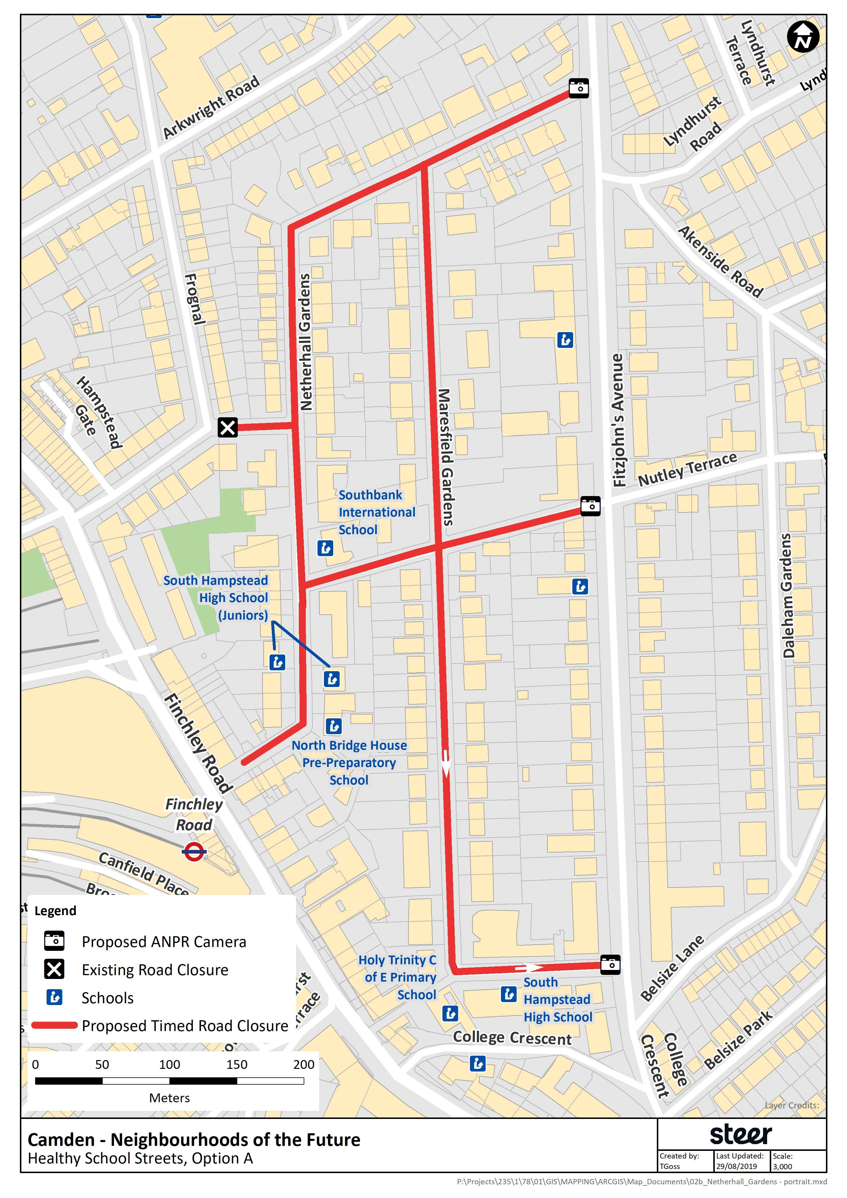
Proposal A - Healthy School Street Zone incorporating Netherhall Gardens, Marsefield Gardens and Nutley Terrace
This proposal uses three ANPR (Automatic Number Plate Recognition) cameras to create a timed road closure on Netherhall Gardens, Maresfield Gardens and Nutley Terrace from the junctions with Fitzjohn’s Avenue, creating a Healthy School Streets zone which incorporates five school sites.
The proposed closures would be for an hour and a quarter in the morning and an hour and a quarter in the afternoon to coincide with the schools opening and closing times from 8.00am to 9.15am and 3.00pm to 4.15pm Monday to Friday during school term time only.
The streets coloured red in Option A on the plan will be restricted during these times to all non-exempt vehicles at the junctions of: (i) Netherhall Gardens and Fitzjohn’s Avenue, and (ii) Nutley Terrace and Fitzjohn’s Avenue. This will be enforced through the use of ANPR cameras in these locations. Vehicles which are not exempt will receive a Penalty Charge Notice (PCN) for entering the zone during the restricted times. The existing (permanent) closure to motor vehicle traffic of Netherhall Way at the junction with Frognal will be retained. Although Maresfield Gardens is already “exit only” onto Fitzjohn’s Avenue, we have proposed placing an ANPR camera at the Maresfield Gardens and Fitzjohn’s Avenue junction as well in order to prevent vehicles driving through the prohibition into the zone from this direction. With existing other (permanent) restrictions onto Frognal/Finchley Road already in place, this proposal creates a zone of (timed) road closures surrounding the streets which these 5 schools are on. All vehicles already within the zone at the restricted times will be able to leave the zone via any exit onto Fitzjohn’s Avenue. All exempt vehicles will be able to access any part of the zone from the permitted entrance points off Fitzjohn’s Avenue (Nutley Terrace and Netherhall Gardens) at any time during the timed road closure e.g. any resident with a registered vehicle in the zone is fully exempt.
A full list of exemptions and details on taxi use in the restricted zone during the times of operation are noted in the 'additional information' document below.
Option B – as Option A but including the southern part of Frognal
Again proposed closures would be for an hour and a quarter in the morning and an hour and a quarter in the afternoon to coincide with the schools opening and closing times from 8.00am to 9.15am and 3.00pm to 4.15pm Monday to Friday during school term time only.
This option builds upon the zone proposed in Option A by extending the zone to incorporate the southern section of Frognal between Arkwright Road and (up to but not including) Hampstead Gate. Option B plan shows the proposed roads which make up the restricted zone highlighted in red. This zone includes all the proposals in Option A plus the section of Frognal noted above, and is proposed for consideration as it would then remove the ability for parents using Frognal as a pick up and drop off location, making use of the existing (retained) motor vehicle restriction on Netherhall Way. As with Option A, exemptions apply
Why your views matter
THIS IS YOUR OPPORTUNITY TO COMMENT
The Council will be pleased to hear your views on the proposals we are consulting on as well as any alternative suggestions or objections you may have to any aspect of this scheme. The response submission deadline for this consultation is 31 OCTOBER 2019.
RESPONSE SUBMISSION:
Please submit your response to this consultation by 31.10.19 via one of the following three options below:
Option 1 Online – submit your response by answering a series of consultation questions and providing your comments on the online survey - link located below
Option 2 Email – submit your response via email to: TransportConsultations@camden.gov.uk
Option 3 Post responses accepted up to 1st November– submit your response using the following free post address (no stamp required): Freepost LBC MAILROOM with Neighbourhoods of the Future, Transport Strategy Service in the bottom left corner of the envelope.
Please Note: if you are responding on behalf of an organisation, only ONE reply will be accepted. You must give your full postal address when responding to the consultation if you want us to consider your views.
Who is being consulted?
All properties properties located close to the proposals, within the consultation area outlined HERE should recieve the consultation leaflet by post. Ward Members, businesses, schools in the area, local and statutory groups will also be consulted.
While it will not be possible to reply to you individually, all comments will be taken into account. Please only write to us with matters associated with this consultation. If you do have any further questions or require clarification about the proposed scheme, please do not hesitate contact Michelle Jamieson on the above contact details. At the end of this consultation period, a report will be written analysing the comments received and officers’ recommendations. This report will be presented to the Cabinet Member for a Sustainable Camden who will make a decision whether or not to proceed with the scheme.
Under the Local Government Access to Information Act 1985, your consultation response will be available for inspection if required; however, your personal details will remain confidential.
Data Protection Act 1998 – All information gathered in this consultation will only be used for the purpose it was collected for.
Areas
- All Areas
Audiences
- Anyone from any background
Interests
- Business and local economy
- Community and living
- Council and democracy
- Education
- Environment
- Housing
- Leisure
- Policing and public safety
- Social care and health
- Transport and streets
Share
Share on Twitter Share on Facebook