
Holborn Liveable Neighbourhood STARter Project Consultation- St George the Martyr C of E School Healthy School Street
Results updated 3 Mar 2026
During March 2025 we consulted on changes proposed for the St George the Martyr Church of England Primary School Healthy School Street Scheme.
Thank you to everyone who took the time to share their views. We had over 40 responses and following the consultation, we have made the decision to implement the proposed changes as a trial.
The new scheme will now be implemented and a notification will go to all local residents and businesses. You can read the decision reports relating to this, and our feedback to the consultation responses in the decision report.
Links:
Overview
We are seeking your views on proposals to introduce a trial Healthy School Street scheme (timed restrictions to motor vehicles) on the streets around St George the Martyr C of E Primary School. We are also proposing various other safer, healthy streets changes in the area.
In line with our Camden Transport Strategy, Climate Action Plan, and Clean Air Strategy and Clean Air Action Plan, and to continue supporting safe, healthy, and active travel, we have been making changes across Camden as part of our Safe and Healthy Streets Programme. In addition, the 2025-2028 CTS Delivery Plan outlines the Council’s commitment to continue to deliver Healthy School Streets with the vast majority of projects aimed to be delivered by 2026.
Healthy School Streets (HSS) create a safer and healthier environment by temporarily closing roads to motor traffic outside schools during drop-off and pick-up times. This enables more children to walk, cycle or scoot to school, with less air pollution, road danger, congestion, and more space for people to interact. HSS help to discourage car trips, particularly amongst parents and carers, by providing a safe and inviting space for more walking, cycling, and scooting.
There are now 31 HSS in the borough, 35 of those schools have timed or permanent road closures. The data that we have collected on these schemes has shown that they can: have a positive impact on reducing traffic levels outside schools, contribute to improved air quality and are often supported by pupils who want us to do more to improve their journey to school.
About the proposed St George the Martyr C of E Primary School Healthy School Street
We are working in partnership with Great Ormond Street Hospital for Children to help improve public health in the area through the delivery of safer, healthier streets including these proposals for a HSS (trial motor vehicle restrictions) for St George the Martyr Church of England Primary School, alongside a ‘Clean Air for Schools’ package of educational activities in the school.
These proposals also help deliver the ambitions of the Holborn Liveable Neighbourhood (HLN) programme. The proposed HSS and wider safer, healthier streets improvements suggested in this consultation are one of our “STARter” HLN projects which are ones we want to deliver first.
We have already engaged with the school community, to present the aims and objectives of HSS programme. At a school assembly, a survey was undertaken among 136 Year 1 to Year 6 school pupils on how they travel to school and their perceptions of the traffic and the streets around the school. The survey results show that majority of pupils walk/scoot to school and think that a HSS would make the streets outside better. For more information on this, please refer to the Related section of this page.
We have collected traffic count data at several locations in the area across an average week during school term time which shows that traffic levels on these streets are at their peak on most days around school run times. Figure 1 below outlines data collected on Millman Street where the main school entrance is located.
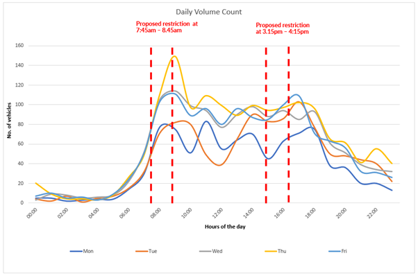
Figure 1 – Millman Street average Weekday Daily Traffic Levels, week commencing 17/09/2024
For Millman Street, traffic data (in Figure 1) shows that traffic volumes increase during school drop off times in the morning at over 106 vehicles (weekday daily average). The traffic levels also increase at school pick up times on some days, reaching 79 vehicles (weekday daily average) between 3.15-4.15pm.
We have also received a request for an HSS on Millman Street from a local resident, concerned about vehicles speeding in front of St George the Martyr C of E Primary school on Millman Street and difficulties faced by children crossing the street.
What are we proposing for the Healthy School Street?
Having carried out the above monitoring, and in line with our ambition to roll out Healthy School Streets to all feasible schools by 2026, we are proposing a trial timed HSS with motor vehicle restrictions on all of Millman Street, Rugby Street and Great Ormond Street (between Lamb’s Conduit Street and Millman Street) between 8:30am – 9:30am and 3pm – 4pm, Monday to Friday during school term times only.
There are two school entrances, an administrative and visitor entrance on John’s Mews and the main pupil entrance on Millman Street. The proposed HSS restrictions aim to reduce traffic in front of the pupil entrance on Millman Street, along with the streets leading to that entrance. Although John’s Mews is not the pupil entrance, the school building is situated on that street, so we‘re proposing other Safe and Healthy streets improvements, such as making that section of John’s Mews one-way southbound for motor traffic (and two-way for cyclists). This would reduce the through traffic and help to make the area around the school safer and healthier.
The drawings of the proposed scheme can be found in the Related section of this page.
The proposed trial scheme would include relevant signage alerting all road users to the restrictions and ANPR (automatic number plate recognition) cameras for traffic enforcement at the start of each restricted section of the streets. The trial HSS signage would state the times of the road closures and would be closed during school holidays and Bank Holidays.
We propose to trial the changes using an Experimental Traffic Order (ETO) for a period of up to 18 months, at which point a decision would be made whether to make the scheme permanent, remove it entirely, or keep it with some changes.
If the trial proposals are approved for implementation following this consultation, we would carefully monitor the impacts of the scheme through traffic volume monitoring both on the restricted roads and those nearby.
The following vehicles would be exempt from the timed Healthy School Street restrictions by applying for an exemption.
- Vehicles registered to properties and businesses on the sections of the streets within the timed restriction area (exemptions would need to be applied for and agreed with the Council)
- Vehicles belonging to parents with a Blue Badge who have a pupil attending St George the Martyr C of E Primary school, or parents/carers of pupils of this School that have a disability that prevents them from walking, cycling, or scooting to school (exemptions would need to be agreed with the Council)
- Emergency services such as ambulance, fire brigade or police, Door to door services such as Plus Bus and Dial A Ride and refuse collection vehicles and other statutory services will be automatically exempt.
School staff and visitors to the schools would not be exempt. Taxis and delivery vehicles would not be exempt, and such trips would need to be scheduled outside of the restricted times, or the vehicles would need to be parked outside of the restricted area. However, exemptions can be applied for in exceptional circumstances, such as when elderly or disabled people may need essential taxi journeys during the restricted hours. All the requests for exemptions can be applied for by contacting the Healthy School Streets team over the phone or via email. If the project goes ahead, details of how to apply for an exemption will be posted to residents and businesses in the consultation area.
The following photo shows an example of an existing HSS, showing how the proposal could look. Similar signage is proposed to be installed as a part of this scheme.
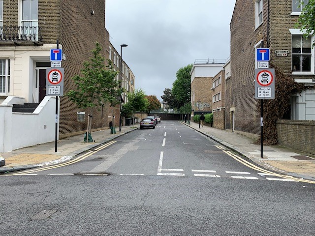
Photo of Healthy School Street
Other proposed permanent Safe and Healthy Street changes in the area
In addition to the above proposed trial timed HSS restrictions, we are also proposing additional permanent changes in the area to reduce traffic dominance, improve pedestrian and cycle accessibility, road safety and air quality, including:
- Adding six cycle hangars to provide secure cycle storage for residents. We’re proposing three new cycle hangars on Millman Street (outside 32 Millman Street), replacing one paid for parking bay and 3.5m of single yellow lines; one cycle hangar on Great Ormond Street (outside 4 Great Ormond Street) by removing one paid for parking bay; and two cycle hangars on Rugby Street by relocating one resident parking bay further west on Rugby Street to replace single yellow lines. Residents in this part of Camden have told us that they would like to have more lockable bike parking close to where they live. We know that a lack of somewhere covered and secure to keep bikes can discourage people from taking up cycling.
- Making John’s Mews between Northington Street and Roger Street, one way southbound for motor traffic and keeping it two way for cyclists. This would prevent northbound through-traffic, thereby reducing overall traffic volumes on this street. Retaining two-way for cyclists on John’s Mews would ensure continued cycle connectivity in the area.
- Providing contraflow (two-way) cycling on Rugby Street which is a one-way street, to improve cycle permeability in the area and connectivity to the school on Millman Street. To do this, we propose to remove parking around the junction of Millman Street with Rugby Street to ensure road safety and visibility of two-way cyclists on this corner:
- Two resident permit holders bays would be removed from Millman Street near the junction with Rugby Street and replaced with double yellow lines.
- One resident’s parking bay would be relocated from Rugby Street near the junction with Millman Street and replaced with double yellow lines; the parking bay would be relocated further west on Rugby Street replacing single yellow lines (near junction with Emerald Court)
- Installing a continuous pavement on Great James Street at the junction with Theobald’s Road, along with two way cycling on Great James Street. Continuous pavement helps to show pedestrian priority and you can see an example in the photo guide in the related section below.
- As a part of the Council’s Junction Protection Programme, we also propose replacing single yellow lines with double yellow lines around the following junctions and streets. The Junction Protection Programme removes parking within 10 metres of all junctions to improve visibility and road safety for all road users.
-
- on one side (western) of John’s Mews between Northington Street and Roger Street, and on both sides near the junction with Northington Street.
- On one side (northern) of Rugby Street and on both sides at the junction of Rugby Street and Millman Street
- On both sides of Great James Street at the junction with Theobold’s Road and at junction with Northington Street
- On both sides of Northington Street
- On both sides of North Mews and Kings Mews at the junction with Northington Street
- On both sides of Roger Street
- On both sides of Doughty Street and John’s Street at the junction with Roger Street
- On both sides of Brownlow Mews and North Mews at the junction with Roger Street
- On eastern side of entire North Mews
- On one side (southern) of Great Ormond Street (Between Millman Street and Lamb’s Conduit Street)
The above proposed changes can be viewed on the consultation drawing in the Related section at the bottom of the page.
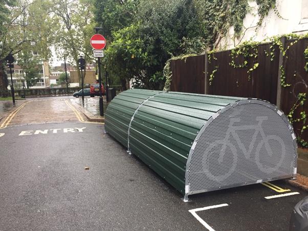
The following photo shows an example of cycle hangars that provide covered, secure and lockable cycle parking on streets.
Why your views matter
Your views matter in helping us shape streets around St George the Martyr C of E primary school and the surrounding area to help people to walk, wheel, cycle or scoot safely while also improving the attractiveness and biodiversity of the local area, helping reduce and mitigate the impacts of climate change, poor air quality and road danger.
To view the plans and to find out more about what the proposal would achieve, click on the links in the Related Section at the bottom of this page.
How would these changes be made?
After the consultation, we will carefully consider the responses, alongside other information including relevant data, safety audits and policy context, to help us in deciding on whether or not to progress the scheme.
A decision report will be produced and published online via our website. Local residents and stakeholders will be notified of the outcome.
Should a decision be made to proceed, we would implement the changes under a permanent Traffic Management Order (TMO).
For information on how we will use data collected from this consultation read our privacy statement: Data protection, privacy and cookies - Camden Council
What happens next
After the consultation, a decision report will be produced and published online via our website. Local residents and stakeholders will be notified of the outcome. The report will consider a broad range of information including officer observations, consultation responses, relevant policies, and other data/information.
Areas
- Holborn and Covent Garden
Audiences
- Anyone from any background
Interests
- Transport and streets
Share
Share on Twitter Share on Facebook