
Safe and Healthy Streets Consultation - Bucknall Street area
Results updated 11 Jun 2024
During November and December 2023 we consulted on changes proposed for the Bucknall Street area.
Thank you to everyone who took the time to share their views. We had over 25 responses and following the consultation, we have made the decision to implement the proposed changes.
The new scheme will now be implemented and a notification will go to all local residents and businesses. You can read the decision reports relating to this, and our feedback to the consultation responses in the decision report.
Links:
Overview
We want our streets to have more safe space for everyone to walk and cycle, for children to get to and from school safely and healthily, for businesses to be able to flourish, to reduce carbon emissions from vehicles and for you to be breathing cleaner air.
We want our streets to provide a lasting legacy of greener, safer, healthier travel.
69% of households in Camden do not own a car, and around 85% of all trips by Camden residents are made on foot, by bike or on public transport. Supporting and encouraging those who can walk and cycle, by creating safer and healthier streets, will also help ensure that there is more space available on public transport and on our roads for those who need it the most.
In line with our Camden Transport Strategy, Climate Action Plan, and Clean Air Strategy and Clean Air Action Plan, and to continue supporting safe, healthy, and active travel following the pandemic, we have been making changes across Camden as part of our Safe and Healthy Streets Programme.
The buildings formerly known as Castlewood House (77-91 New Oxford Street) and Medius House (63-69 New Oxford Street) have been demolished and are being replaced by a new building (to be known as The Earnshaw) comprising a mixture of uses including office, retail, restaurant, and residential (planning reference 2017/0618/P). The Council has secured funding via a legal agreement relating to the planning permission to deliver Pedestrian, cycling, public realm, and environmental improvements in the Bucknall Street area.
Currently a Santander cycle hire docking station with 18 docking points is located on Earnshaw Street at the junction with Bucknall Street. However, this needs to be relocated to Bucknall Street to facilitate the introduction of a pocket park which is being privately funded as part of the development described above.
Bucknall Street (east of Dyott Street) and Dyott Street are currently one-way streets for all vehicles, with no exemptions for cycling. This reduces accessibility for people who cycle in the area. Bucknall Street and St Giles High Street are also part of important walking routes in the area, which provide crucial links between the British Museum/Russell Square, and Holborn and Tottenham Court Road stations. It is currently difficult for the high volumes of pedestrians to cross Earnshaw Street, between St Giles Square and the Bucknall Street area.
We have therefore developed proposals for Safe and Healthy Streets improvements in the Bucknall Street area. This includes junction alterations and pavement widening, a new pedestrian zebra crossing, the relocation of a Santander cycle hire docking station, the introduction of a rain garden (a rain garden captures and store rainwater, acts as great local habitat for wildlife and improves the look and feel of an area) and tree planting, as well as cycle access improvements.
We are now consulting on the following proposed permanent changes in the Bucknall Street area:
Walking changes:
- Junction improvements including the introduction of a raised table (see photo guide for example) on Earnshaw Street at the junction with Bucknall Street to slow traffic and make it easier, safer, and more enjoyable for pedestrians to cross the road at this location.
- Pedestrian crossing improvements on Earnshaw Street near St Giles High Street to slow traffic and make it easier, safer, and more enjoyable for pedestrians to cross the road at this location. This would include pavement widening, and the introduction of a zebra crossing on a raised table (to help slow traffic speeds and emphasise pedestrian priority).
- Further pavement widening on Bucknall Street and St Giles High Street to provide more space for pedestrian movements.
Cycling and vehicle access changes:
- Relocation of the Santander cycle hire docking station with 18 docking points to the north side of Bucknall Street to facilitate construction of a pocket park (to be delivered by the developer of the adjacent properties formerly known as Castlewood House and Medius House). This would maintain this important transport option for the local community and visitors to the area.
- Introducing two-way cycling (contraflow cycling- where the traffic only flows one-way) on the section of Dyott Street between Bucknall Street and Shaftesbury Avenue (southbound cycle contraflow) and on the section of Bucknall Street between Dyott Street and Shaftesbury Avenue (westbound cycle contraflow). This would improve accessibility for people who cycle, helping them to travel more easily and safely in both directions on these sections of street which are currently one-way for all vehicles, while also helping to make the streets safer and healthier.
- Changing the section of Bucknall Street between Dyott Street and Earnshaw Street, where traffic currently flows two-way, to one-way eastbound for all traffic with a westbound cycle contraflow (where people cycling can travel in both directions).
- Makee the section of Dyott Street between Bucknall Street and New Oxford Street, where traffic currently flows one-way southbound, to cyclists only (motor vehicles prohibited). This would also help create a motor-traffic free section of Dyott Street that benefits pedestrians (existing pavements would be retained).
Planting and greening changes:
- Widening the pavement and adding planting on Bucknall Street and St Giles High Street (subject to ground condition surveys), including the introduction of a rain garden with low level planting and further street trees (subject to ground condition surveys) on a widened pavement on the north side of St Giles High Street adjacent to Central St Giles Piazza. These proposals would help to address a key objective of Camden’s Climate Action Plan by helping to provide shade and shelter on our streets, and removing some CO2 out of the atmosphere, helping to tackle the climate crisis. Adding new plants and trees would create more areas which could soak up water during heavy rainfall. They would also contribute to improvements in air quality, improve local biodiversity by adding new habitats for nature and improve how the area looks and feels. Rain gardens and trees also help to soften hard landscapes and help to make walking more enjoyable.
Loading, Parking and Road Marking changes:
- Permanently removing six resident permit holder parking spaces and three pay-by-phone parking bays from Bucknall Street to facilitate the proposed pavement widening and relocation of the Santander cycle hire docking station. The majority of these parking spaces have been suspended for circa 4 years during construction work at the properties formerly known as Castlewood House and Medius House. The parking suspensions are scheduled to remain in place until 31st May 2024.
- Relocation of the parking bay for dockless rental e-bikes and e-scooters from Bucknall Street to Dyott Street, to help enable pavement widening on Bucknall Street whilst retaining this local shared transport facility.
- Introduction of a disabled parking bay on Bucknall Street adjacent to the new building to be known as The Earnshaw
- Introduction of a loading bay adjacent to 2-4 Bucknall Street
You can view drawings of the scheme proposals in the Related section at the bottom of this page. Further details on Santander cycle hire docking stations, rain gardens, and our cycle permeability programme are also provided below.
About the proposed Santander cycle hire docking station relocation
Our Transport Strategy and Cycling Action Plan outline measures to support cycle hire options in the Borough to increase availability and access to bikes for residents and visitors. The Council and Transport for London (TfL) are working together to expand TfL’s network of cycle hire docking stations across the borough.
The cycle hire docking station to be relocated from Earnshaw Street to Bucknall Street would maintain a sustainable and healthy alternative to motor vehicles, enabling more journeys to be undertaken by residents and visitors to the Borough, and contributing to the Cycling Action Plan and targets to increase cycling.
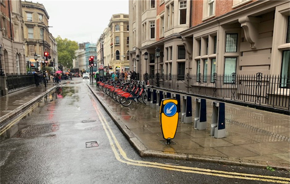
Photo of a cycle hire docking station on a pavement buildout/ extension on Great Russell Street
About the proposed rain garden on St Giles High Street
The Council previously consulted on proposals which formed part of the West End Project to plant trees on the pavement on the north side of St Giles High Street adjacent to Central St Giles Piazza. Two trees have recently been planted at this location.
We are adding more plants and trees across our streets to help minimise water runoff. One way to do this is to increase the amount of on street water storage to soak up water when severe rains arrive, which the climate crisis makes more likely. To reduce risk in the Bucknall Street area, we have identified an opportunity to install a new rain garden including some additional trees at the above location on St Giles High Street.
Rain gardens capture and store rainwater, function as great local habitats for wildlife, and improve the look and feel of an area. They can also have a positive effect in reducing public exposure to air pollution in some environments, as well as bringing additional benefits through increased biodiversity, improved mental health and wellbeing, and absorbing carbon dioxide from the atmosphere at pavement level.
The proposed rain garden including plants and trees would be constructed on a pavement buildout and would be similar in design to the photo below.
Photo of a rain garden
About our Cycle Permeability Programme
Many streets in the borough are one-way for vehicles and links between streets on desired routes and Camden’s cycle network are often severed by infrastructure, traffic restrictions or highly trafficked major roads. The cycle permeability programme, which forms part of our Cycling Action Plan, aims to make more Camden streets more accessible to people who cycle and provide better connections and links through measures such as adding two-way cycling on one-way streets and cut-throughs at physical road closures. A number of such permeability improvements for people who cycle have been made in recent years at various locations across the borough. One such example near Bucknall Street and Dyott Street is Bedford Avenue where two-way cycling was introduced between Adeline Place and Bloomsbury Street in December 2020. This provided a continuous and direct two-way cycle link between Bloomsbury Street and Tottenham Court Road.
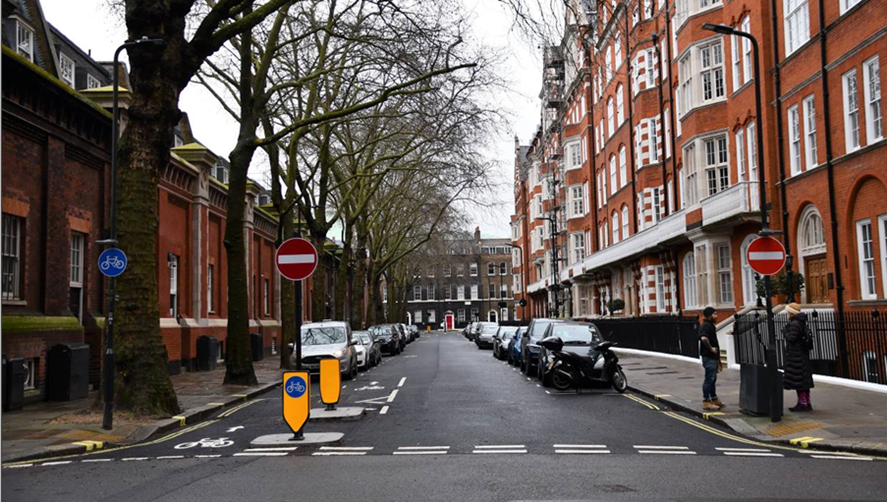
Photo of a cycle permeability measure on Bedford Avenue (two-way cycling on a one-way street)
Why your views matter
As 69% of households in Camden do not own a car and public transport usage remains lower than pre-pandemic, we know that providing infrastructure and improvements that enable safe and easy walking, wheeling, cycling, and scooting on key routes within the borough, such as the Bucknall Street area, are more important than ever. Supporting and encouraging those who can walk and cycle, by creating safer streets, will ensure that there is more space available on public transport and on our roads for those who need it the most.
Your views are important in providing feedback both on the proposed scheme as a whole, and specific elements of it, and we would therefore welcome your responses to the consultation questionnaire.
To view the plans and find out more about what each proposal would achieve, click on the links in the Related Section at the bottom of this page.
After the consultation, a decision report will be produced and published online, via our website. Local residents and stakeholders will be notified of the outcome. The report will consider a broad range of information including consultation responses, feedback received, relevant policies and other data/information including surveys and any relevant monitoring information.
All of this information will be considered in making a recommendation in the report about whether or not to implement the scheme. Should a decision be made to proceed, we would implement the changes under a permanent Traffic Management Order (TMO) in Spring 2024. If approved for construction, we would then carefully monitor the changes to make sure they operate effectively.
For information on how we will use data collected from this consultation read our privacy statement: Data protection, privacy and cookies - Camden Council
What happens next
After the consultation, a decision report will be produced and published online via our website. Local residents and stakeholders will be notified of the outcome. The report will consider a broad range of information including officer observations, consultation responses, relevant policies, and other data/information.
While it will not be possible to reply to you individually, all comments will be considered. At the end of this consultation period, officers will consider all responses received and make amendments to the proposal if necessary. Officers will then review responses received relating to the consultation and a report with recommendations will be prepared. This report will be presented to the Director of Environment and Sustainability (Supporting Communities Directorate) who will decide whether or not to proceed with implementing the proposals.
If approved, the proposed measures would be introduced in Summer 2024.
Areas
- Holborn and Covent Garden
Audiences
- Anyone from any background
Interests
- Transport and streets
Share
Share on Twitter Share on Facebook