
Eton Avenue Area Safe and Healthy Streets Scheme
Overview
To answer the consultation questions click the link at the bottom of this page.
We want our streets to have more safe space for everyone to walk and cycle, for children to get to and from school safely and healthily, for businesses to be able to flourish, to reduce carbon emissions from vehicles and for you to be breathing cleaner air.
We want our streets to provide a lasting legacy of greener, safer, healthier travel.
As 69% of households in Camden do not own a car and public transport use remains much lower than before the pandemic, we know that safe and easy walking, cycling and scooting routes are more important than ever. Supporting and encouraging those who are able to walk and cycle, by creating safer streets will ensure that there is more space available on public transport and on our roads for those who need it the most.
Why your views matter
We want to improve the streets around Eton Avenue, Lambolle Place, Lancaster Grove, Merton Rise, King’s College Road and Strathray Gardens to make it easier, safer and more accessible for people walking and wheeling to travel in the area.
We would like to make changes that:
-
Improve the safety and accessibility for walking, wheeling and scooting on the streets in this area, especially for caregivers and small children.
-
Improve the look and feel of the streets in the area, and make it more attractive for people who live, work, study and spend time here.
-
Improve the biodiversity of the area by introducing more plants and trees.
Eton Avenue Area
Eton Avenue and Strathray Gardens are residential streets located in Belsize Park. We want to make it easier, safer and more accessible for people walking and wheeling to travel in the area, especially around the various local schools in this area and to/from the nearby underground stations.
In addition to improving the walkability and accessibility of these roads, Camden Bike Bus use these roads as part of its weekly cycle route during school drop-off and pick-up times. There are several schools in the area, and young children taking part in the Camden Bike Bus either travel with their carers or independently.
Strathray Gardens, which joins Eton Avenue on its eastern side, has a wide crossing distance of approx 22m at the junction with Lancaster Grove. Wider junctions can encourage speeding and unsafe driving, while creating longer crossing distances for people walking and wheeling. Longer crossing distances are especially challenging for vulnerable road users and disabled people, further highlighting the need for improved crossings in this area.
The scheme would introduce new planting areas, creating a vibrant ‘pocket park’ for the community. Local mapping shows a clear shortage of public green spaces in our neighbourhood, so this project would help address that gap and make the area more welcoming for residents and the various school communities in the area.
A key feature of the design is the proposal for rain gardens, also known as SuDS (Sustainable Urban Drainage Systems). These will deliver two important benefits:
-
Environmental: providing shade, reducing urban heat, improving air quality, and supporting biodiversity.
-
Practical: reducing pressure on the rainwater drainage system.
Rain gardens are an excellent sustainability asset and ideally suited to the site’s natural slope.
Rain Gardens would enhance climate resilience, improve surface water management, and significantly upgrade the appearance and amenity of the space. These improvements would also represent a major step toward a greener, healthier, and more resilient community environment.
Our proposals for Eton Avenue, Strathray Gardens and the streets nearby are as follows:
Lancaster Grove junction with Eton Avenue and Lambolle Place:

Converting the existing traffic triangle at Lambolle Place (between Eton Avenue and Lancaster Grove) into a small public space with new green areas, seating, play features, new lighting, sustainable drainage and new trees (tree locations subject to available depth for utilities). To achieve this, we would need to remove the car club bay (containing 2 car club parking spaces) and make this section of Lambolle Place car-free.
-
Widening pavements with additional planting, new trees on Eton Avenue and introducing a parallel zebra crossing to the west of the Sarum Hall school gate to support children and carers during school drop-off and pick-up.
-
Adding a raised crossing and widening the pavement outside No.14 Eton Avenue to give people a safer and more accessible crossing. To achieve this, there would need to be a loss of 4 resident parking spaces at this junction.
-
Adding a cycle 2 hangars on Eton Avenue to the west of the traffic triangle, to accommodate high demand from residents on the waiting list. To achieve this, there would need to be a loss of 0.5 resident parking spaces.
-
Widening pavements, adding plants and trees, pencil shaped bollards, seating and cycle stands on Eton Avenue outside of the school (running the full length of the school wall). To achieve this there would need to be a loss of 4 resident parking spaces here and the removal of the 1 existing bus bay.
-
Adding new double yellow lines with single kerb markings for No Loading 8am - 9am and 3pm - 4pm Monday - Friday, outside of Sarum Hall School to create a space clear of motor vehicles outside of the school wall
-
Introducing a continuous pavement across Lancaster Grove at Eton Avenue to give pedestrians a safer and more accessible crossing. This is where the pavement continues over the road. You can see an example in the photo guide at the bottom of the page.
-
Adding raised crossings and widening the pavement outside of No. 8 on Lancaster Grove to make it easier to cross the road. To achieve this, there would need to be a loss of 3 resident parking spaces at this junction.
Merton Rise junction with Eton Ave

-
Adding a new continuous pavement across Merton Rise at Eton Avenue, to create a safe crossing point for people walking and wheeling and planted areas and a cycle hangar, to accommodate high demand from residents on the waiting list. To achieve this, there would need to be a loss of 4 resident parking spaces at this junction to improve visibility.
Eton Ave between Merton Rise & King’s College Road

-
Adding a new raised crossing with widened pavements on Eton Avenue outside Springfield Court to create a safe crossing point for people walking and wheeling. To achieve this, there would need to be a loss of 4 resident parking spaces.
Strathray Gardens junction with Eton Avenue & King’s College Road junction with Eton Avenue

-
Introducing a new continuous crossing over Strathray Gardens at Eton Avenue to show that people walking and wheeling have priority.
-
Widening pavements and adding plants and trees at this junction to provide shade and to promote local biodiversity. To achieve this, there would need to be a loss of 7 resident parking spaces at this junction and 1 paid-for parking space.
-
Adding a new raised crossing in between Strathray Gardens junction with Eton Avenue and King's College Road junction with Eton Avenue to give people a safer and more accessible crossing. To achieve this, there would need to be a loss of 2 resident parking spaces.
-
Adding a new continuous crossing over King's College Road at Eton Avenue to show that people walking and wheeling have priority.
-
Adding one cycle hangar outside of Eton Court to the west of Eton Avenue at the junction with King's College Road to accommodate high demand from residents on the waiting list.
Strathray Gardens junction with Lancaster Grove

-
Introducing a continuous crossing over Strathray Gardens at Lancaster Grove to show that people walking and wheeling have priority. To achieve this, there would need to be a loss of 1 resident parking space.
-
Widening pavements to provide space for walking and wheeling and adding a new tree at this junction to provide shade and promote biodiversity
Parking changes
Making the above changes would require the removal of a total of 31 resident parking spaces in the area, leaving 344 resident bays with 276 Active resident parking spaces. This is considered sufficient to cater to the number of active permits in the area. 1 car club bay (2 car club parking spaces) would also need to be removed
1 Bus bay currently outside of Sarum Hall school on Eton Avenue would be removed as this is no longer being used. New double yellow lines with single kerb markings for No Loading 8am - 9am and 3pm - 4pm Monday Friday, are proposed further east outside of Sarum Hall school. This new space would be approximately 20m long.
Adding plants and trees
Planting at various locations is proposed, including rain gardens along Eton Avenue and at several junctions where we are proposing widening the pavements.
We are proposing to plant up to 17 new trees across the area to provide shade. An example rain garden is pictured below.

The proposed changes are illustrated in the Eton Avenue Area Consultation Plans document. We have also put together a photo guide that shows what some of proposed changes could look like, such as a parallel zebra crossing and raised continuous crossings. Links to these documents are provided at the bottom of this page.
Changes for drivers and people cycling
All driving routes would stay the same except Lambolle Place, on the western side of the traffic triangle on Eton Avenue which would be closed to motor vehicles and become access to people cycling and pedestrians only.
To view the plans click on the links in the Related Section at the bottom of this page.
After the consultation, a decision report would be produced and published online via our website. Local residents and stakeholders would be notified of the outcome. The report would consider a broad range of information including officer observations, consultation responses, relevant policies, and other data/information.
For information on how we would use data collected from this consultation read our privacy statement: Data protection, privacy and cookies - Camden Council
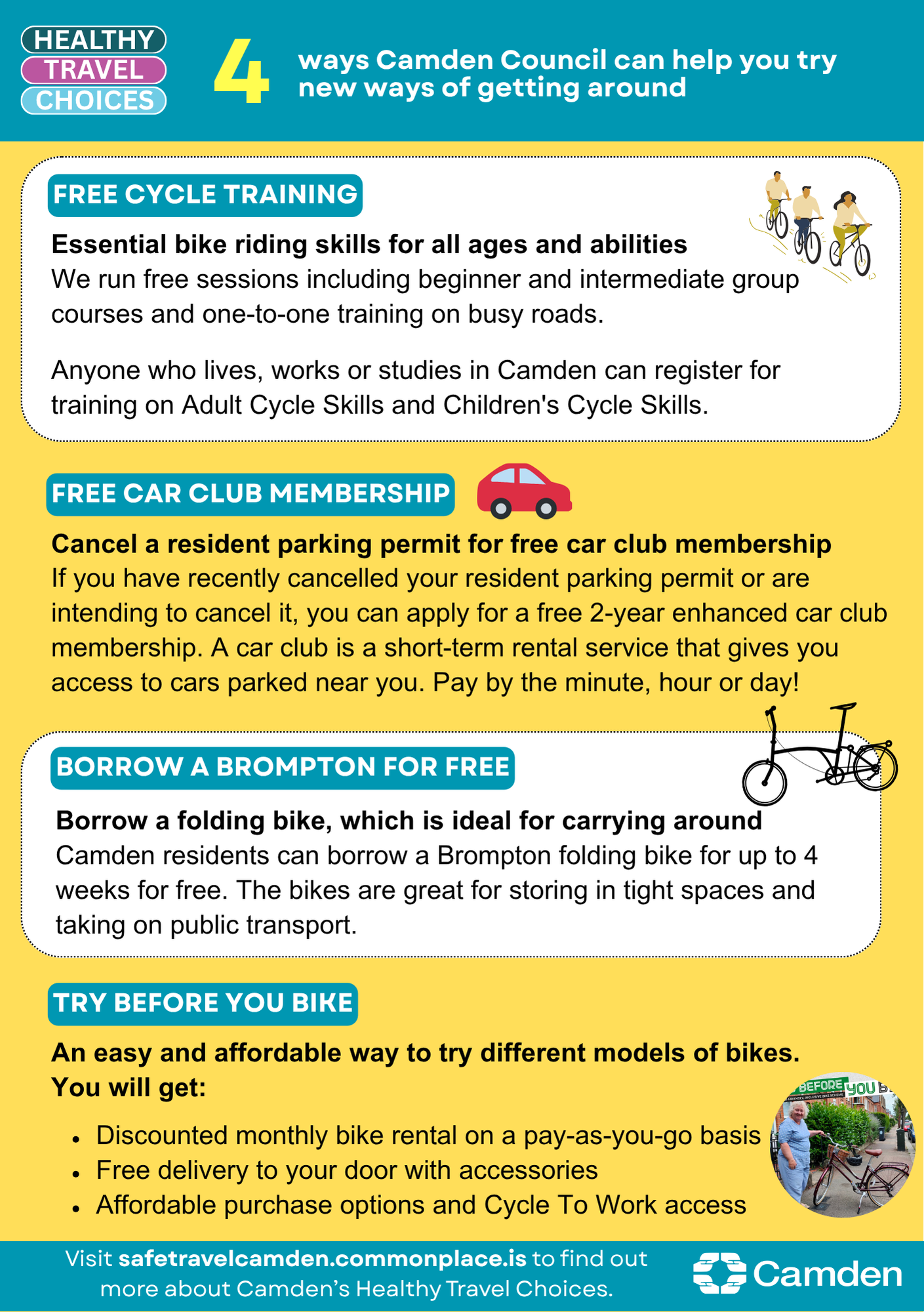
Supporting you in travelling differently
We have lots of different ways we want to support you to travel healthily, explore all the latest offers on our website.
To view the plans click on the links in the Related Section at the bottom of this page.
After the consultation, a decision report will be produced and published online via our website. Local residents and stakeholders will be notified of the outcome. The report will consider a broad range of information including officer observations, consultation responses, relevant policies, and other data/information.
For information on how we will use data collected from this consultation read our privacy statement: Data protection, privacy and cookies - Camden Council
Supporting you travelling differently
We have lots of different ways we want to support you to travely healthily, explore all the latest offers on our website.
What happens next
After the consultation, a decision report will be produced and published online via our website. Local residents and stakeholders will be notified of the outcome. The report will consider a broad range of information including officer observations, consultation responses, relevant policies, and other data/information.
Areas
- Belsize
Audiences
- Anyone from any background
Interests
- Transport and streets
Share
Share on Twitter Share on Facebook