
Haverstock Hill/ Rosslyn Hill Walking, Cycling and Road Safety Scheme Consultation - Permanent Proposals
Results updated 18 Sep 2023
During May 2023 we consulted on changes proposed for Haverstock Hill / Rosslyn Hill.
Thank you to everyone who took the time to share their views. We had over 670 responses and following the consultation, we have made the decision to implement the proposed changes permanently.
The new scheme on Haverstock/Rosslyn Hill will be implemented from Spring 2024 and a postcard will be sent to all local residents and businesses. You can read the decision reports relating to this, and our feedback to the consultation responses in the decision report.
Links:
Overview
CONSULTATION EXTENDED: We are aware that our consultation website was unavailable from early Friday 5th till mid-morning Tuesday 9th May. During this period we were working hard with our IT team to understand the problem and resolve it. We are continuing to liaise with the website supplier to ensure that we can to put in place robust safeguards to make sure such a long downtime does not happen again as well as closely monitoring the site to ensure that it is available throughout the remainder of the consultation period.
We apologise for any inconvenience caused, in particular if you tried to access the Haverstock Hill consultation during this time. Because of the issue with our website we will be extending the closing date of the Haverstock Hill consultation to the end of Sunday 28th May.
Proposals to make the trial changes to Haverstock Hill/ Rosslyn Hill permanent, and a range of new Safe and Healthy Street proposals.
We want to transform our streets so they have more, safe space for everyone to walk and cycle, for children to get to and from school safely, for you to be breathing cleaner air, to reduce carbon emissions from road transport, and for businesses to flourish. We want to ensure that our streets support recovery from the pandemic and provide a lasting legacy of greener, safer, healthier travel.
We have been trialling changes on Haverstock Hill and Rosslyn Hill to help make streets safer and healthier by improving junction layouts, upgrading pedestrian crossing points and adding new cycle lanes to make getting around safer and easier.
We are now consulting on making the following trial changes permanent, as well as proposing new measures in this area to improve conditions for walking as well as cycling.
We are proposing to keep a number of the changes we tested, including:
- Mandatory cycle lanes, on either side of Haverstock Hill/ Rosslyn Hill, between the junctions with Prince of Wales Road and Pond Street.
- The removal of traffic islands at formal and informal crossings.
- Pedestrian countdown facilities at signalised junctions with England’s Lane and Pond Street and at the signalised pedestrian crossings near the junctions with Glenloch Road and Ornan Road.
- Wider advanced stop lines and early release facilities for cyclists (where cyclists are given a green light before the rest of the traffic) at the junctions with England’s Lane and Pond Street.
- The removal of two inset paid for parking bays, with space converted to pavement.
- The removal of pavement buildout at the junction with Belsize Grove to provide space for cycle lane.
- The conversion of 2 bus stops (Bus Stop W and Q) on the western side of Haverstock Hill within the scheme area to Shared Use Bus Boarders (SUBBs) (see photo guide for example).
- Extending the hours of operation of the bus lane on Rosslyn Hill from Mon-Fri 3pm-7pm to Mon-Sun 24/7.
- The paid for, residents, disabled parking and loading spaces that were relocated to the adjacent side streets.
- The disabled parking and loading provision that was retained on Haverstock Hill/ Rosslyn Hill during the trial.
- Provision of seating for people to stop and rest.
- Short stay cycle parking to help people switch their journey to the shops by bike.
Following feedback received and lessons learned during the scheme, we are proposing to upgrade some of the features that we trialled but also making a number of further changes.
Permanent proposals for improvements for the Public Realm
- Install green spaces along the route including the area at the junction of Haverstock Hill and Belsize Avenue; adding permeable paving around tree pits (see photo guide for example) to increase space for pedestrians and to protect tree roots. This is to improve air quality, biodiversity, provide shade and enhance the public realm of the street (subject to trial holes to determine available spaces).
- Install around 5 new benches to provide opportunities to rest, particularly for the elderly and people with disability.
- Raise the road level and add a new road material (see photo guide for example) on Haverstock Hill from the junction with Howitt Road to the Old Town Hall (213 Haverstock Hill). This is to calm the traffic and improve the look of the area with high quality materials befitting of the high street. This would make the area feel less of a ‘through route’ and more of a shopping destination to encourage people to visit more often.
- Widen the pavement in the space left by the relocated coach bay outside Village Prep School on Parkhill Road and add rain garden (see photo guide for example), cycle stands and benches. This is to provide a place for parents and students to rest and park bikes and to improve biodiversity and sustainable drainage. The coach bay would be relocated to Eton Road adjacent to St Saviour's Church, where there is currently a single yellow line and a resident parking bay. The resident parking bay will be moved 10 metres to provide space for the coach bay on the single yellow line. This is to provide a pick-up/drop-off location for coaches associated to a local school.
Permanent proposals for improvements for Pedestrians
- Raise the existing pedestrian crossings north of Eton Road, north of Steeles Road, south of Upper Park Road, south of Belsize Grove and south of Ornan Road. This is to slow the traffic and improve crossing locations for pedestrians accessing nearby facilities.
- Change the raised zebra crossing, outside of Royal Free Hospital, to a raised signalised crossing (subject to Transport for London approval). This is to provide an improved crossing for people accessing Royal Free Hospital and Hampstead Hill School.
- Add new continuous footways (see photo guide for example) across Eton Road, Downside Crescent, Howitt Road, Glenloch Road, Aspern Grove and Rowland Hill Street to reduce vehicle speeds and provide pedestrian priority.
- Add new raised tables (see photo guide for example) across Upper Park Road, Belsize Avenue, Ornan Road and Belsize Lane to reduce vehicle speeds and make it safer and easier for pedestrians to cross.
- Add double yellow lines with double blip markings (no parking/waiting at any time) at junctions with side roads to prevent vehicles from parking and loading at the junctions. This will provide a safer crossing at junctions for pedestrians.
Permanent proposals for improvements for Cycling
- Replace the ‘kerb and wand’ cycle lane segregation with raised stepped cycle tracks (see photo guide for example). This is because ‘kerb and wands’ get dirty quickly and are easily broken, and stepped cycle tracks provide a better ride quality and a more useable width. This can also improve emergency vehicle response times (vehicles can pull over onto the cycle tracks to allow emergency vehicles through). Providing raised stepped cycle tracks would also bring the cycling facilities up to the same standard as the other implemented cycling facilities (and those under construction) on the borough’s primary cycling network.
- The stepped cycle track is proposed to be redirected behind the new parking and loading bays in two locations on Haverstock Hill. This is to provide greater protection for cyclists from moving traffic whilst improving the provision for parking and loading near the high street
- Install around 6 new cycle stands along the route to enable more people to park their cycles while visiting the area.
- Install one new bike hangar (see photo guide for example) on Parkhill Road near the junction with Haverstock Hill, adjacent to an existing bike hangar. This is to provide local residents with safe and secure cycle storage and in response to the demand.
Permanent proposals for improvements for Public Transport
- Upgrade Bus Stop K, outside 191 Haverstock Hill, from a Shared Use Bus Boarder (SUBB) to a bus stop bypass (see photo guide for example) and install low level planting. This is to provide safe continuous cycling and improve biodiversity and provide sustainable drainage.
- Introduce double yellow lines with double blips markings (no parking/waiting at any time) along the 24/7 bus lane so that buses are not delayed by parked vehicles.
Permanent proposals for improvements for Motor Vehicles
- Introduce two new disabled parking bays, two new loading bays and 20 metres of new paid for parking bays in form of ‘floating’ bays on the west side of Haverstock Hill between Belsize Grove and Howitt Road. 'Floating' bays are parking bays located between the cycle lane and the vehicle traffic lane. See photo guide for example.
- Introduce one new disabled parking bay, two new loading bays and two new paid for parking bays in form of 'floating' bays on the west side of Haverstock Hill between Glenloch Road and Belsize Avenue.
- Introduce one new timed loading bay on the east side of Haverstock Hill, outside of 194 Haverstock Hill, directly adjacent to the existing loading bay.
- Introduce one new timed loading bay on the east side of Haverstock Hill, outside of 240 Haverstock Hill.
- Extend the hours of the loading bay outside the Old Town Hall (213 Haverstock Hill) to 24 hours, 7 days per week.
- Convert one shared-use residents’ / paid for parking bay on Steeles Road to a paid for parking bay.
The proposed new disabled bays are in addition to the two disabled bays installed during the trial which are to be retained, bringing the total number of disabled bays on the corridor and adjacent side streets to 18.
The map below shows retained, relocated and proposed new disabled bays (P icon) and loading bays (pin icon) along the corridor and on side streets. Click top left icon to view the key/legend or each icon to view details.
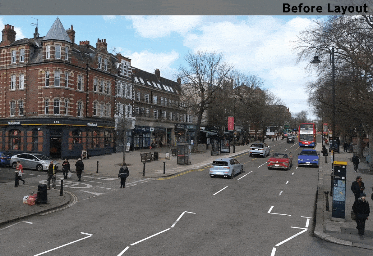
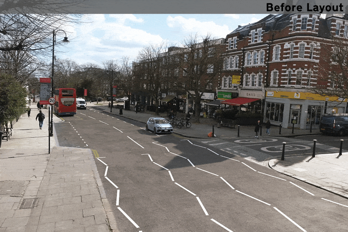
Below you can view visualisations of the proposed changes to the scheme which will automatically change while you watch. They will show you what the area looked like before the scheme, what it looks like now and what the permanent proposals would look like, if approved following consultation.
Location: On Haverstock Hill near Glenloch Road looking northbound.
Location: On Haverstock Hill near Howitt Road looking southbound.
Why your views matter
As 64% of households in the borough do not own a car and public transport patronage levels remain lower than before the pandemic, we know that safe and easy walking, cycling and scooting routes are more important than ever. Supporting and encouraging those who are able to walk and cycle, by creating safer streets will ensure that there is more space available on public transport and on our roads for those who need it the most.
The final decision on whether to go ahead with the proposals contained in this consultation will be made based on evidence including engagement and consultation responses, relevant policies, officer observations, and other data/information including monitoring information collected over the course of the trial.
Your views are important in providing feedback both on the proposed scheme as a whole and elements of it, and we would therefore welcome your responses on the pages that follow.
To view the plans and find out more about what each proposal would achieve, click on the links in the Related Section at the bottom of this page.
What happens next
After the consultation, a decision report will be produced and published online via our website. Local residents and stakeholders will be notified of the outcome. The report will consider a broad range of information including consultation responses, feedback received during the trial period, relevant policies and other data/information including monitoring information collected during the trial period.
All of this information will be considered in making a recommendation in the report about whether, at the end of the trial period, the experimental scheme should be made permanent, modified or allowed to lapse.
Areas
- Belsize
- Gospel Oak
- Hampstead Town
- Haverstock
Audiences
- Anyone from any background
Interests
- Transport and streets
Share
Share on Twitter Share on Facebook