
Fitzrovia Area Safe and Healthy Streets - Phase 2 Consultation
Results updated 30 Jul 2026
During February and March 2026 we consulted on changes proposed for the Fitzrovia area.
Thank you to everyone who took the time to share their views. We had over 40 responses and following the consultation, we have made the decision to implement the proposed changes permanently.
The new scheme will now be implemented and a notification will go to all local residents and businesses. You can read the decision reports relating to this, and our feedback to the consultation responses in the decision report.
Links:
Overview
We want our streets to have more safe space for everyone to walk and cycle, for children to get to and from school safely and healthily, for businesses to be able to flourish, to reduce carbon emissions from vehicles and for you to be breathing cleaner air.
As 69% of households in Camden do not own a car and public transport use remains much lower than before the pandemic, we know that safe and easy walking, cycling and scooting routes are more important than ever. Supporting and encouraging those who are able to walk and cycle, by creating safer streets will ensure that there is more space available on public transport and on our roads for those who need it the most.
We want our streets to support a lasting legacy of greener, safer, healthier travel.
In line with our Camden Transport Strategy, Climate Action Plan, and Clean Air Action Plan, and to continue supporting safe, healthy, and active travel following the pandemic, we have been making changes across Camden as part of our Safe and Healthy Streets Programme.
Why your views matter
Fitzrovia Area Safe and Healthy Streets Project– Phase 2
Fitzrovia is a distinctive and vibrant area with a mix of land uses including offices, residential, retail and food and drink. We want to make it easier, safer and more accessible for people walking and wheeling to travel in and around the area.
The recent development at 100 Tottenham Court Road has enabled the Council to secure funding from the developers called - Section 106. We are proposing to use this funding to improve the look and feel of the local area and make it safer and easier to travel here including:
- Improving the safety and accessibility for walking, wheeling and cycling in this area.
- Improving the look and feel of the streets making it more attractive for people who live, work, study and spend time here.
- Improving local biodiversity by introducing more plants and trees.
The Fitzrovia Area Safe and Healthy Streets project is already making it safer and easier for people who cycle and pedestrians to get around. It consists of two parts:
Phase 1 was consulted on during May / June 2024 and is currently being constructed.
This consultation now sets out our proposals for Phase 2 with changes across the area including Chitty Street, Whitfield Street, Tottenham Street and Scala Street, plus our call for ideas to improve Goodge Place.
These are our proposals for permanent changes in the Fitzrovia area:
Chitty Street
- Restricting motor vehicle access into and out of Chitty Street at its junction with Charlotte Street using bollards - cycles would be permitted. This would reduce through-traffic, making the street safer for pedestrians and cyclists, and supporting a quieter, healthier local environment.
- Introducing street art on the road at key points along Chitty Street. This would enhance the street’s character, create a sense of place and make the area more enjoyable for residents and visitors. The street art on our proposal plans are just an idea, and we would welcome your suggestions on designs that best reflect the character and identity of the location.
- Installing a raised crossing at the junction of Chitty Street and Whitfield Street where the road is raised to make crossing easier for pedestrians (for example see the photo guide). Also adding a zebra crossing at the junction of Chitty Street and Charlotte Street. This would calm traffic and make it safer and easier for people to cross, particularly for those with mobility needs and families with children.
- Adding a new pocket park – This would be a widened area of pavement with trees, plants and places to sit. The pocket park would offer people a place to relax, socialise, or simply enjoy nature. Example images can be found in our photos guide. This space could only be created by restricting the motor vehicle access.

Photo of a Fleet Valley Pocket Park, Camden
-
- This pocket park would include Rain Gardens – this is where we add SuDS (Sustainable Drainage Systems) and plants which capture rainwater and provide essential water storage.
- By increasing the amount of on street water storage to soak up water when severe rains arrive, which the climate crisis makes more likely, we would be reducing the risk of local flooding.
- Permeable block paving doesn’t just capture and store rainwater but also improves the look and feel of the area. These surfaces can help reduce public exposure to air pollution, support improved mental health and wellbeing by creating greener, more inviting spaces, and absorb carbon dioxide from the atmosphere at pavement level.
- The proposed pocket park, featuring a variety of plants and trees, would be constructed on widened sections of pavement and would be similar in design to successful examples already in place elsewhere, including the one in the photo above.
Whitfield Street
- Widening pavements with permeable paving (which allows water to drain away) and new trees on the eastern section of Whitfield Street between Chitty Street and Tottenham Street. This would provide more space for pedestrians, improve accessibility and enhance the street’s appearance. New trees are proposed near the existing nursery at the junction with Chitty Street (subject to ground condition surveys), helping to create a more inviting and sheltered environment for children and families, improving air quality and contributing to local climate resilience.
Tottenham Street
- Creating a pedestrian and cycle-only space on Tottenham Street between Tottenham Court Road and Whitfield Street. This would reduce traffic volumes, improve safety for people walking and cycling, and create a more pleasant, accessible public space. The proposed pedestrian and cycle-only zone would connect to existing pedestrian space at Whitfield Gardens, providing a continuous space for pedestrians and cyclists, enhancing connectivity through the area and supporting a safer, greener local environment.
- Creating a continuous walking route between Whitfield Gardens and Goodge Street by providing a uncontrolled crossing on Tottenham Street to link Tottenham Mews and Goodge Place. (see photo guide for example)
Scala Street
- Converting Scala Street to a one-way street (westbound), while allowing cycling both ways, to create a safer environment for those on foot or on bike.
- Widening the pavement and adding benches, new trees and public street art at eastern end of Scala Street to help create a more attractive, welcoming, and people-focused place. The street art on the drawings is just an idea, and we would welcome your suggestions on designs that best reflect the character and identity of the location.
- Introducing continuous pavements (where paving material continues over the road and show pedestrian priority – see out photo guide for an example) on Scala Street at the junction with Charlotte Street to make it easier, safer, and more enjoyable for pedestrians to cross the road at this location. Continuous pavements also help to reducing traffic speeds and conflicts between road users, thereby improving safety for pedestrians and people who cycle
- Review pavement conditions on Scala Street to see what pavement might need replacing to improve the walking surface.
Cycle Parking and Storage
- Installing new dockless bike hire and e-scooter bays at key locations, including on Chitty Street near the Whitfield Street junction, on Tottenham Street to improve facilities near busy Goodge Street station, and on Scala Street to better manage high demand as seen at the frequently overflowing bay on Charlotte Street. These proposals would encourage cycling, support sustainable travel, and help keep pavements clear of parked bikes and scooters.
- Installing five new bike hangars on Chitty Street, Charlotte Street and Goodge Place to provide secure, weather-protected parking for resident bicycles. This would make cycling a more convenient and attractive option for people with limited space in their homes, supporting sustainable travel and reducing bike theft.
The above proposals to include tress and planting would support a key objective of Camden’s Climate Action Plan by helping to provide shade and shelter on our streets, and removing some CO2 out of the atmosphere, helping to tackle the climate crisis. Adding new plants and trees would create more areas which could soak up water during heavy rainfall. They would also contribute to improvements in air quality, improve local biodiversity by adding new habitats for nature and improve how the area looks and feels.
Loading and Parking Changes to support the above changes
- The above proposals would require the removal of a total of 12 resident parking spaces across Whitfield Street, Chitty Street, Tottenham Street, Charlotte Street and Scala Street, leaving 68 resident bays with 60 Active resident parking spaces in this area. This is considered sufficient to cater to the number of active permits in the area. 2 car club bays would also need to be removed on Chitty Street.
- Facilitating a pedestrian zone on Tottenham Street would require relocating the loading bay from Tottenham Street to a new position on the pavement buildout on Whitfield Street. The motorcycle parking bay on Whitfield Street would also be relocated slightly towards Tottenham Street.
- We are also proposing to provide two new disabled parking bays on Chitty Street (subject to separate consultation) to improve accessibility for people with mobility impairments.
- The summary of the parking and loading changes proposed are listed in the table below and can also be seen on the design proposal plans.
|
Location |
Tottenham Street |
Whitfield Street |
Chitty Street |
Charlotte Street |
Scala Street |
Total |
|
|
Resident Permit Parking |
Existing Spaces* |
8 |
5 |
7 |
20 |
||
|
Proposed Spaces* |
5 |
3 |
0 |
8 |
|||
|
Paid for Parking |
Existing Spaces |
5 |
3 |
2 |
10 |
||
|
Proposed Spaces |
0 |
0 |
2 |
2 |
|||
|
Car Clubs Bays |
Existing Spaces |
2 |
2 |
||||
|
Proposed Spaces |
0 |
0 |
|||||
|
Solo Motorcycle |
Existing Spaces |
1 |
1 |
||||
|
Proposed Spaces |
1 |
1 |
|||||
|
Loading Bay |
Existing Spaces |
1 |
0 |
1 |
|||
|
Proposed Spaces |
0 |
1 |
1 |
||||
|
Blue Badge Bay |
Existing Spaces |
1 |
1 |
||||
|
Proposed Spaces |
2 |
2 |
*5.0m equals approx 1 space
Gathering ideas on Goodge Place


Photos of Goodge Place at the junction with Goodge Street (source: Google Street View)
- We would like to seek your views on how Goodge Place/Goodge Street market area could be improved. Early ideas include creating safe and attractive crossing between Goodge Place and Charlotte Place, improving the look and feel of the plan with new paving or road materials, adding seating and planting. We would like to hear your ideas which we would then use to shape proposals for a future consultation.
To view the plans click on the links in the Related Section at the bottom of this page.
After the consultation, a decision report will be produced and published online via our website. Local residents and stakeholders will be notified of the outcome. The report will consider a broad range of information including officer observations, consultation responses, relevant policies, and other data/information.
For information on how we will use data collected from this consultation read our privacy statement: Data protection, privacy and cookies - Camden Council
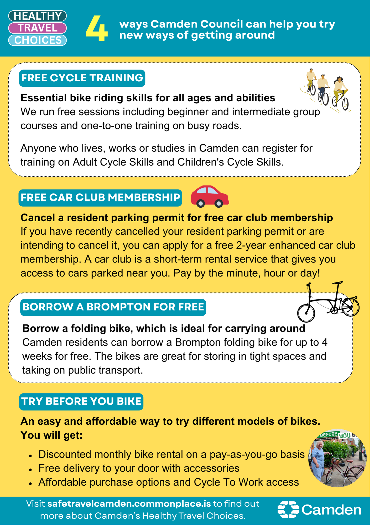
Supporting you travelling differently
We have lots of different ways we want to support you to travely healthily, explore all the latest offers on our website.
What happens next
After the consultation, a decision report will be produced and published online via our website. Local residents and stakeholders will be notified of the outcome. The report will consider a broad range of information including officer observations, consultation responses, relevant policies, and other data/information.
Areas
- Bloomsbury
Audiences
- Anyone from any background
Interests
- Transport and streets
Share
Share on Twitter Share on Facebook